用相机与雷达融合实现高效地图分割,实时性提升260%。
FIN: Fast Inference Network for Map Segmentation
- 基于鸟瞰图空间的轻量级网络架构,融合相机与雷达数据。
- 达53.5 mIoU精度,推理速度比最强基线快260%。
- 适合对实时性要求高的自动驾驶感知系统使用。
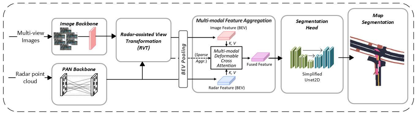
自动驾驶中的多传感器融合日益普遍,以提升感知任务的鲁棒性。相机与雷达融合能以较低成本结合相机丰富的语义信息与雷达精准的距离测量,避免高昂开销和过重数据处理负担。地图分割是实现车辆环境行为有效性的关键任务,但依然面临高精度与实时性难以兼顾的挑战。为此,本文提出一种新型高效的地图分割架构,利用相机与雷达在鸟瞰图(BEV)空间进行融合。模型采用先进的损失函数集与新型轻量级头部结构,显著提升感知性能。实验表明,该方法在保持53.5 mIoU高精度的同时,推理速度相比最强基线提升260%,创下新基准。
原文摘要 · Abstract (English)
Multi-sensor fusion in autonomous vehicles is becoming more common to offer a more robust alternative for several perception tasks. This need arises from the unique contribution of each sensor in collecting data: camera-radar fusion offers a cost-effective solution by combining rich semantic information from cameras with accurate distance measurements from radar, without incurring excessive financial costs or overwhelming data processing requirements. Map segmentation is a critical task for enabling effective vehicle behaviour in its environment, yet it continues to face significant challenges in achieving high accuracy and meeting real-time performance requirements. Therefore, this work presents a novel and efficient map segmentation architecture, using cameras and radars, in the \acrfull{bev} space. Our model introduces a real-time map segmentation architecture considering aspects such as high accuracy, per-class balancing, and inference time. To accomplish this, we use an advanced loss set together with a new lightweight head to improve the perception results. Our results show that, with these modifications, our approach achieves results comparable to large models, reaching 53.5 mIoU, while also setting a new benchmark for inference time, improving it by 260\% over the strongest baseline models.
Thank you to arXiv for use of its open access interoperability. PaperDance 不是 arXiv 官方产品;中文卡片由大模型生成,请以原文为准。