用无人机和街景图像融合分析建筑热风险,助力城市公平应对高温
Assessing Building Heat Resilience Using UAV and Street-View Imagery with Coupled Global Context Vision Transformer
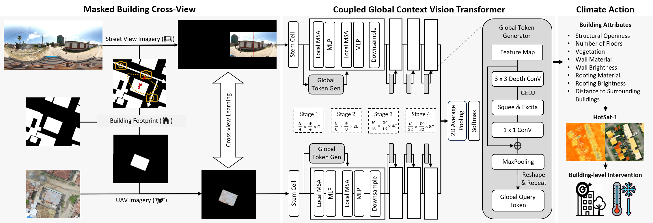
- 通过双模态视觉变压器融合航拍与街景图像,捕捉建筑热特性
- 植被环绕、浅色屋顶、混凝土/陶土/木制屋顶可降低9.3%热辐射值
- 适用于关注气候公平与城市韧性研究的政策制定者和规划者
气候变化正加剧全球南方密集城区的人类热暴露风险,低质建材与高蓄热表面进一步放大该风险。然而,评估此类热相关建筑属性的可扩展方法仍稀缺。本文提出一种机器学习框架,利用开源无人飞行器(UAV)与街景(SV)影像,通过耦合全局上下文视觉变压器(CGCViT)学习城市结构的热相关表征。结合HotSat-1热红外(TIR)测量数据,量化建筑属性与热相关健康风险的关系。双模态跨视角学习方法相比最优单模态模型性能提升最高达9.3%,证明航拍与街景图像对城市结构具有互补价值。有植被环绕的建筑、浅色屋顶、以及混凝土、陶土或木质屋顶,均显著关联更低的HotSat-1 TIR值。在坦桑尼亚达累斯萨拉姆市部署该框架,揭示了因建筑材料差异导致的家庭级热暴露不平等现象,为基于数据的气候适应策略提供支持。
原文摘要 · Abstract (English)
Climate change is intensifying human heat exposure, particularly in densely built urban centers of the Global South. Low-cost construction materials and high thermal-mass surfaces further exacerbate this risk. Yet scalable methods for assessing such heat-relevant building attributes remain scarce. We propose a machine learning framework that fuses openly available unmanned aerial vehicle (UAV) and street-view (SV) imagery via a coupled global context vision transformer (CGCViT) to learn heat-relevant representations of urban structures. Thermal infrared (TIR) measurements from HotSat-1 are used to quantify the relationship between building attributes and heat-associated health risks. Our dual-modality cross-view learning approach outperforms the best single-modality models by up to $9.3\%$, demonstrating that UAV and SV imagery provide valuable complementary perspectives on urban structures. The presence of vegetation surrounding buildings (versus no vegetation), brighter roofing (versus darker roofing), and roofing made of concrete, clay, or wood (versus metal or tarpaulin) are all significantly associated with lower HotSat-1 TIR values. Deployed across the city of Dar es Salaam, Tanzania, the proposed framework illustrates how household-level inequalities in heat exposure - often linked to socio-economic disadvantage and reflected in building materials - can be identified and addressed using machine learning. Our results point to the critical role of localized, data-driven risk assessment in shaping climate adaptation strategies that deliver equitable outcomes.
Thank you to arXiv for use of its open access interoperability. PaperDance 不是 arXiv 官方产品;中文卡片由大模型生成,请以原文为准。