用无配对数据实现多光谱图像超分辨率,提升枯树分割精度。
Multispectral Blind Image Super-Resolution for Standing Dead Tree Segmentation
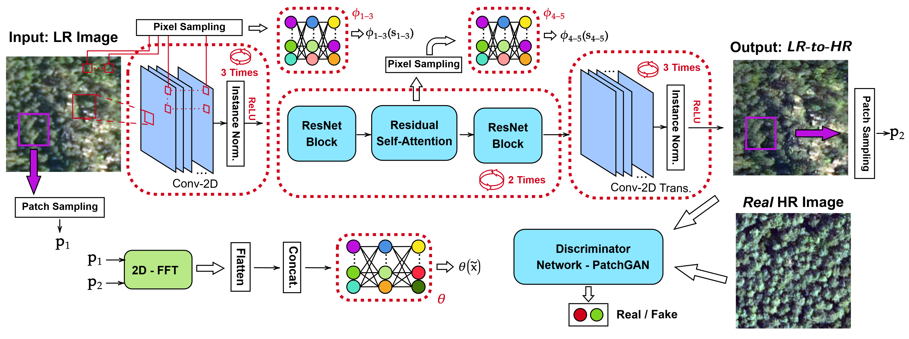
- 基于注意力引导的域适应网络,从无配对低分辨率图像恢复高分辨率多光谱图像。
- 在无高分辨率标注下仍达54%的分割Dice分数,有标注时达64%。
- 适用于低端传感器成像缺陷修复,适合森林生态监测研究者使用。
定位枯树对了解气候变化对森林及生物多样性的影响至关重要。然而,受限于传感器可用性与标注数据稀缺,利用高质量航拍影像进行枯树分割面临挑战。本文提出一种通用的盲超分辨率框架,结合注意力引导域适应网络(ADA-Nets),学习从低分辨率到高分辨率多光谱图像域的映射。该方法仅依赖无配对样本,模拟真实场景——低分辨率图像非通过下采样高分辨率图像生成。此外,所提方法可通用修复多种图像退化问题,包括过曝、噪声和低对比度,常见于低端传感器获取的低分辨率图像。据我们所知,这是首个针对枯树分割任务的真实世界、通用多光谱超分辨率研究。实验表明,分割准确率在无高分辨率标注条件下达54%(采用超分辨率重建图像训练),有标注时达64%。模型与数据集已在Kaggle公开:https://www.kaggle.com/datasets/meteahishali/aerial-imagery-for-dead-tree-segmentation-poland。
原文摘要 · Abstract (English)
Mapping standing dead trees is crucial for acquiring information on the effects of climate change on forests and forest biodiversity. However, leveraging high-quality aerial imagery for dead tree segmentation poses challenges due to limitations in sensor availability and the scarcity of annotated data. In this study, we propose a generic blind super-resolution framework that incorporates Attention-Guided Domain Adaptation Networks (ADA-Nets) to learn the mapping from low-resolution to high-resolution multispectral image domains. Our approach operates solely on unpaired samples, mimicking real-world conditions, i.e., low-resolution images are not synthetically obtained by downsampling the high-resolution images. Moreover, the proposed method serves as a general-purpose restorer addressing several image degradation types, including saturation, noise, and low contrast that typically occur in low-resolution images acquired by low-end sensors. To the best of our knowledge, this is the first study to perform real-world and generic super-resolution for multispectral data in the scope of standing dead tree segmentation. Experimental evaluations demonstrate segmentation performances of 54% and 64% in Dice scores. Notably, the first result is obtained without using any high-resolution annotations; the segmentation network is trained on super-resolved low-resolution images, while evaluation is performed on the high-resolution data. We publicly share the aerial multispectral dataset with manually annotated labels at https://www.kaggle.com/datasets/meteahishali/aerial-imagery-for-dead-tree-segmentation-poland.
Thank you to arXiv for use of its open access interoperability. PaperDance 不是 arXiv 官方产品;中文卡片由大模型生成,请以原文为准。